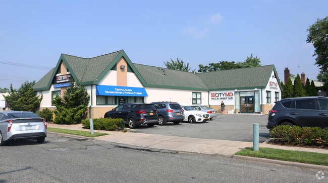
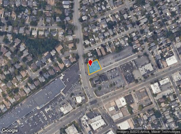
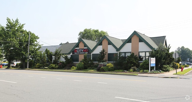
Property Record
292 Herricks Rd, Mineola, NY 11501
NEARBY LISTINGS FOR SALE OR LEASE
Property Detail
292 Herricks Rd
2223-09-018-00-0069-0
TOWN #2 SCH DIST 010
Officebuilding
Nassau
X
New York
36059C0210G
69
2025
0.27 AC
2025
Central Nassau
303500
Long Island (New York)
11,655 SF
Nassau County-Suffolk County, NY
DEMOGRAPHICS near 292 Herricks Rd
1 Mile
3 Mile
5 Mile
2024 Total Population
26,589
188,497
534,056
2029 Population
26,208
184,508
518,529
Pop Growth 2024-2029
(1.43%)
(2.12%)
(2.91%)
Average Age
42
42
42
2024 Total Households
9,342
62,988
171,586
HH Growth 2024-2029
(1.34%)
(2.16%)
(3.06%)
Median Household Inc
$125,564
$130,426
$117,082
Avg Household Size
2.80
2.90
3.00
2024 Avg HH Vehicles
2.00
2.00
2.00
Median Home Value
$735,890
$753,461
$708,035
Median Year Built
1951
1952
1953
Nearby Places
- Restaurants
- Banks
- Shops
- Fitness
- Groceries
PUBLIC TRANSPORTATION
COMMUTER RAIL
Merillon Avenue Station (Port Jefferson Branch - Long Island Rail Road)
DRIVE
WALK
Distance
Merillon Avenue Station (Port Jefferson Branch - Long Island Rail Road)
2 min
0.9 mi
Mineola Station (Oyster Bay Branch - Long Island Rail Road, Port Jefferson Branch - Long Island Rail Road, Ronkonkoma Branch - Long Island Rail Road)
DRIVE
WALK
Distance
Mineola Station (Oyster Bay Branch - Long Island Rail Road, Port Jefferson Branch - Long Island Rail Road, Ronkonkoma Branch - Long Island Rail Road)
4 min
1.6 mi
AIRPORT
John F Kennedy International
DRIVE
WALK
Distance
John F Kennedy International
23 min
13.2 mi
LaGuardia
DRIVE
WALK
Distance
LaGuardia
25 min
15.0 mi
Westchester County
DRIVE
WALK
Distance
Westchester County
55 min
36.2 mi
Freight Ports
NY - Red Hook Container Terminal
DRIVE
WALK
Distance
NY - Red Hook Container Terminal
37 min
23.1 mi
Nearby Properties
Address
Land Use
TOTAL SIZE
Lot Size
Zoning
Address
Land Use
TOTAL SIZE
Lot Size
Zoning
1,667,567 SF
30 AC
R3-2
Address
Land Use
TOTAL SIZE
Lot Size
Zoning
231,865 SF
9.99 AC
C4-1
Address
Land Use
TOTAL SIZE
Lot Size
Zoning
356,093 SF
3 AC
R3-2
Address
Land Use
TOTAL SIZE
Lot Size
Zoning
171,000 SF
2.76 AC
R2A
Address
Land Use
TOTAL SIZE
Lot Size
Zoning
70,734 SF
2.94 AC
R2A
Address
Land Use
TOTAL SIZE
Lot Size
Zoning
90,974 SF
1.73 AC
R2A
Address
Land Use
TOTAL SIZE
Lot Size
Zoning
65,412 SF
3.31 AC
R3-2
Address
Land Use
TOTAL SIZE
Lot Size
Zoning
36,500 SF
2 AC
R2A
Address
Land Use
TOTAL SIZE
Lot Size
Zoning
5,322,666 SF
86.10 AC
Address
Land Use
TOTAL SIZE
Lot Size
Zoning
5.32 AC
R3-2
Address
Land Use
TOTAL SIZE
Lot Size
Zoning
17,000 SF
0.65 AC
R2A
Address
Land Use
TOTAL SIZE
Lot Size
Zoning
1,197,283 SF
64.50 AC
Address
Land Use
TOTAL SIZE
Lot Size
Zoning
574,353 SF
65 AC
Address
Land Use
TOTAL SIZE
Lot Size
Zoning
13,075 SF
0.22 AC
C8-1
Address
Land Use
TOTAL SIZE
Lot Size
Zoning
10,230 SF
0.51 AC
R2A
Address
Land Use
TOTAL SIZE
Lot Size
Zoning
1.86 AC
R3-2
Address
Land Use
TOTAL SIZE
Lot Size
Zoning
23,691 SF
0.50 AC
R2A
Address
Land Use
TOTAL SIZE
Lot Size
Zoning
556,575 SF
11.46 AC
Address
Land Use
TOTAL SIZE
Lot Size
Zoning
12,616 SF
0.46 AC
R3-2
Address
Land Use
TOTAL SIZE
Lot Size
Zoning
9,020 SF
0.23 AC
R2A
Address
Land Use
TOTAL SIZE
Lot Size
Zoning
14,460 SF
0.54 AC
R2A
Address
Land Use
TOTAL SIZE
Lot Size
Zoning
7,740 SF
0.46 AC
R3-2
Address
Land Use
TOTAL SIZE
Lot Size
Zoning
36,955 SF
1.78 AC
R2A
Address
Land Use
TOTAL SIZE
Lot Size
Zoning
680,630 SF
72.68 AC
Address
Land Use
TOTAL SIZE
Lot Size
Zoning
7,222 SF
0.36 AC
R3-2
Address
Land Use
TOTAL SIZE
Lot Size
Zoning
11,554 SF
0.35 AC
R2A
Address
Land Use
TOTAL SIZE
Lot Size
Zoning
11,587 SF
0.23 AC
R2A
Address
Land Use
TOTAL SIZE
Lot Size
Zoning
7,500 SF
0.23 AC
R3-2
Address
Land Use
TOTAL SIZE
Lot Size
Zoning
9,750 SF
0.64 AC
R2A
Address
Land Use
TOTAL SIZE
Lot Size
Zoning
13,695 SF
0.23 AC
R3-2
The World's #1 Commercial Real Estate Marketplace
Connect with us
© 2025 CoStar Group
The information above has been obtained from sources believed reliable. While we do not doubt its accuracy we have not verified it and make no guarantee, warranty or representation about it. It is your responsibility to independently confirm its accuracy and completeness. Any projections, opinions, assumptions, or estimates used are for example only and do not represent the current or future performance of the property. The value of this transaction to you depends on tax and other factors which should be evaluated by your tax, financial, and legal advisors. You and your advisors should conduct a careful, independent investigation of the property to determine to your satisfaction the suitability of the property for your needs.